Cylindrical
Projection
A map is a
representation of a place or a location. There are different types of maps and also
have different uses. Maps are called
projections because they have to project
a 3-D surface on to a
2D map.
The 3 kind of projections are: cylindrical, conic
and planar.

The cylindrical projection is
a type of map
in which the geometric figure
(cylinder) is wrapped around the
earth, and the details are projected
into a a cylindrical surface.
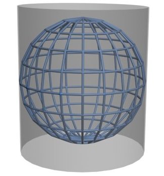
The cylinder is unwrapped into a
flat surface. And has a
lot of distortion in the polar regions.

One type of cylindrical
projection is the Mercator
Projection. Was created by
Gerard Mercator by 1569 and was used during the Century XVIII on the
nautical navigation.

This
kind of projection is
a type of a rectangular map in which the
lines of altitude and
latitude intersect at right angles .
Polar areas also been distorted.

The Robinson projection is
a pseudocylindrical
projection, that was first
made in 1963 by Arthur H Robinson.

The Robinson projection is also called the Orthophanic projection.
In this map the lines of latitude are parallel
to the equator, but lines of longitude are
elliptical arcs. The compass lines are curved and that’s why are distorted.
In a cylindrical
projection the parallels and meridians appearing
as a straight lines perpendicular to each other if the cylinder is tangent over the sphere at
the equator and all parallels as well as
the points of the poles if shown appearing as the same length as the
equator (1)
CONCLUSIONS
I understand with this information that there are some types of maps that are used to represent the earth and specially the cylindrical projection was used in the navigation because has continue straight lines.

But due the map is unfolded and represented in a rectangle the polar areas are distorted. And in the century XVIII Mercator was used these cylindrical projections.
I hope you enjoy this information.
References
(1)Definition of CYLINDRICAL PROJECTION
In-text: ("Definition Of CYLINDRICAL PROJECTION")
Your Bibliography: "Definition Of CYLINDRICAL PROJECTION". Merriam-webster.com. N.p., 2016. Web. 18 Oct. 2016.
Your Bibliography: "Definition Of CYLINDRICAL PROJECTION". Merriam-webster.com. N.p., 2016. Web. 18 Oct. 2016.
(2)Proyección cartográfica
In-text: ("Proyección Cartográfica")
Your Bibliography: "Proyección Cartográfica". Es.wikipedia.org. N.p., 2016. Web. 18 Oct. 2016.
Your Bibliography: "Proyección Cartográfica". Es.wikipedia.org. N.p., 2016. Web. 18 Oct. 2016.
(3)Cylindrical equal-area projection
In-text: ("Cylindrical Equal-Area Projection")
Your Bibliography: "Cylindrical Equal-Area Projection". En.wikipedia.org. N.p., 2016. Web. 18 Oct. 2016.
Your Bibliography: "Cylindrical Equal-Area Projection". En.wikipedia.org. N.p., 2016. Web. 18 Oct. 2016.
Blog created by: Paola Hellmund Gómez.
18/10/2016
7. B.
No hay comentarios.:
Publicar un comentario